


(SI F06) La Thuile - Rifugio Elisabetta

SityTrail - itinéraires balisés pédestres
Tous les sentiers balisés d’Europe GUIDE+
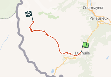

Length
17 km

Max alt
2605 m

Uphill gradient
1197 m
Km-Effort
31 km

Min alt
1442 m

Downhill gradient
491 m
Boucle
No

Signpost
Creation date :
2022-02-15 16:36:28.454
Updated on :
2022-03-01 19:16:48.46
6h57
Difficulty : Medium

FREE GPS app for hiking
 SityTrail
IGN / Geographical institutes
SityTrail Plus
The world is yours!
About
Trail On foot of 17 km to be discovered at Aosta Valley, Unknown, La Thuile. This trail is proposed by SityTrail - itinéraires balisés pédestres.
Description
Sentiero Italia CAI 2019
Photos
 La Thuile - Rifugio Elisabetta - Photo 1")
 La Thuile - Rifugio Elisabetta - Photo 2")
 La Thuile - Rifugio Elisabetta - Photo 3")
 La Thuile - Rifugio Elisabetta - Photo 4")
 La Thuile - Rifugio Elisabetta - Photo 5")
 La Thuile - Rifugio Elisabetta - Photo 6")
 La Thuile - Rifugio Elisabetta - Photo 7")
 La Thuile - Rifugio Elisabetta - Photo 8")
 La Thuile - Rifugio Elisabetta - Photo 9")
 La Thuile - Rifugio Elisabetta - Photo 10")
Positioning
Country:
Italy
Region :
Aosta Valley
Department/Province :
Unknown
Municipality :
La Thuile
Location:
Unknown
Start:(Dec)
Start:(UTM)
340206 ; 5064764 (32T) N.
Comments